Manitoba's
Obukowin Lake
|
| Go
to Part: 1 2 3 4 5 6 |
More Canoe Stories |
Maps for this trip |
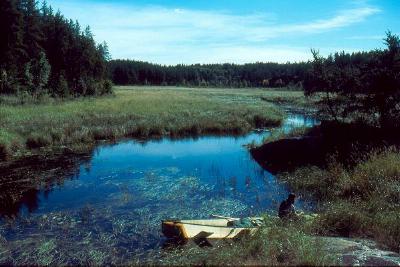
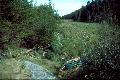
The small, slow rivers of Woodland Caribou Park are places of mystery and imagination. Hidden in the bland ink of a topographical map are places of flat, swampy land where rivers meander, winding back and forth, sometimes wide and deep, but often narrow and shallow. Late in the season plants grow tall. The domain of the canoe traveler shrinks down and presses close. People become small, like mice making their way through a field of tall grass. And just as mice, people become alert and alive, smelling the heavy air, their eyes darting back and forth, straining to see beyond the next curving loop. Every small detail is observed and explored and savored. As eyes strain, the mind also strains, making pictures of what may be, grasping at each smell and sound, remembering all other wilderness rivers it has seen, and imagined and dreamed. In some places topographical contour lines come close to a river. In these small valleys, rocky shores stand against a narrow horizon, a metropolis of granite not bustling and noisy, but still and quiet and serene. Trees cling to these shores, sometimes tall and grand, sometimes twisted and gnarled and toughened and old. Gardens of moss may soften and color this city of boreal life, soaking up water as it trickles from above and soaking up the whispers of passing canoe travelers. When moving with the current, paddlers may find plenty of water to fill their trail. The canoe may even glide along the water as people relax and enjoy the river. But the deep water does not belong to people, it belongs to the beaver. Soon canoe travelers may hear the faint sound of rushing water ahead. And soon they find the beaver dam that made their travel so easy. If the dam is small and shallow a few quick strokes of the paddle might let them glide across. Some dams are huge and tall. The canoe must be unloaded on the top and dragged to the bottom. Now travel might be hard with little water. The paddlers are now walkers, their feet sink into the soft river bed as they struggle and stumble and pull the canoe into deeper water. Gradually the water deepens and travel is easy, until they again hear the faint sound of rushing water ahead... I wake up to the soothing sound of water flowing in the rocky channel behind our camp. My eyes open to a warm green glow as sunlight touches the top of our tent. It's a great morning for sitting on a wilderness shore with a cup of coffee and a map and a plan for traveling. Within a few minutes I'm doing just that, tracing out our route along the Wanipigow River. Other travelers have been through this winding stream. Their journals tell me that we may have a long day making our way to Siderock Lake. Our trip on the Wanipigow will be quite different today, but now, our day is unknown as I sit and trace the lines, as I lift my eyes to watch the sun as it lights up the distant shore.
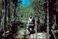
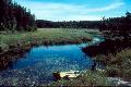
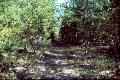
Soon we're on the 925 meter portage into Crystal Lake. Throughout our trip, Mike and I have single portaged whenever possible. Doing a portage in one trip takes some planning and dicipline, and I've only been able to pull it off when traveling with Mike. Since we're both carrying over 36 kilograms of gear (about eighty pounds), it helps to be in shape. Our dicipline in packing and visits to the YMCA are paying off, although at times I miss the return trip where I can stop and look around and enjoy the woods. On this portage, one small place is so beautiful that I put down the canoe and ask Mike to wait for a few pictures. Closed in from the sky by tall pines and covered in ferns and moss, it's a place taken right out of a children's storybook, a small world that stops you and tells you its story as you stand and relax and forget how old you are. Mike walks ahead as I don my pack and pick up the canoe. Soon he's stopped again. Something is moving through the woods, cracking branches and brushing against the trees. A moose? Our single portage puts us into Crystal Lake by nine-thirty. Crystal Lake has a spattering of islands on it's western end that reminds me of a place in Quetico Park, a pleasant spotted shore I found years ago in McKenzie bay in Kawnipi Lake. There's a tent up on one of the tall islands and we go by quietly, looking for people. We see no one. Although we saw signs of people and heard their generator on Caroll Lake, we've actually seen no people on this trip since we left Siderock Lake. Now we'll follow the Wanipigow River back to Wallace Lake. After reading Martin Kehoe's journal of a trip through this country, I'm expecting a seven hour pull to make it to Siderock. I'm hoping that we'll pull into camp around five o'clock. The Wanipigow first offers us a nice channel and we paddle into it. The channel ends on a boulder field and it doesn't look like we can get through. I realize that we must have passed the first portage. We soon find it on the north side of the river and it delivers us to a wide, grassy portage landing. It's sunny and warm with a little wind. Another boulder field appears and we walk through, dragging and straining to lift the canoe into deeper water. On one portage we stumble through lowland grass, clumpy and full of holes. We look for a landing with enough water to float the canoe. I follow the "shore" of this grassy area, keeping just a meter or so uphill of the lowest area. The footing is better here, although slightly slanted. Just before the no-name lake on the Manitoba side of the border, we land in a place with hardly any water. The river flattens here and we walk for about a hundred and fifty meters, holding the canoe and pulling it, then floating it beside us. It's twelve-thirty now; we've been on the river about three hours. the wind is up as we cross the no-name lake. Past the no-name lake the contour lines pull close and high rock walls close us in. Another boulder field appears, but travelers from days gone by have cleared a path that allows us to float right through.
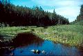
Now the river snakes through tall fields of cattails that form a wall, closing in our small canoe as we twist and scrape through loops and over boulders. We hear water rushing ahead and expect that a beaver dam might soon be blocking our way. Instead, we're surprised by a small, high-falling waterfall. Evidently our long, steady rain near the start of our trip is paying off now, spilling water into the river and giving us an easy float. A small, grassy valley leads us to the last portage. We're back in the fire zone now, but the land still brings a smile as we take a breather on a high smooth rock. By two o'clock we're at Siderock Lake. The wind is really up now and I'm concerned about the last leg of our trip - crossing wallace lake from northeast to southwest. We might end up with our gunwales facing the wind, a bad way to ride across a large lake. We might have to zig-zag our way across to keep our canoe on top of the water. The wind seems to be coming mostly from the west, and we'll be heading right into it as we make our way across Siderock. I want to stay close to shore in this wind, but following the northeastern shore would bring us close to rough water. The wind is raising waves that even now are crashing against the eastern shore. Martin Kehoe's journal mentioned a portage from Wallace to Siderock but I'm not sure where it begins. If Mike and I follow the southern shore, we can make it to the west side of the lake and get out of the wind. If the wind really is from the west, we can take the portage, then follow the western shore of Wallace back to our take-out point. We tighten our life jackets and head into the wind. The travel is hard and we strain and pull. I'm not confident that we'll make much progress, but then I never had a paddling partner with as much strength and stamina as my son. We do pretty well, fighting for each meter, but the meters pass and become kilometers and they too pass. There are two small bays on the far western shore of Wallace Lake. After poking our nose into the southern bay, we move north and Mike searches the shore with a monocular. There's a flash of orange and soon we're at a nice grassy landing and loading up. This portage is a cake walk, smooth and flat with a canopy of small trees to close around us. Our easy paddle along the western shore of Wallace is not to be. Instead we face a stiff wind and big waves that splash into our loaded canoe. We wait for our moment then shove off and paddle hard into the wind. Now the wind seems to come more northerly, but we again ride well and a hard hour later we find our take out point among the confusing jumble of civilization. It's four-thirty. Many hours later, after again driving into the night, we find a small motel in Kenora, Ontario. It's amazing to me that we woke up on a portage landing in Broken Arrow Lake, and now rest our heads on pillows, having walked and paddled and driven our way through Ontario and Manitoba. Cars and trucks pass in the night, their faint roar drifting into our Spartan room. But I don't hear them. Instead, buried in my slumber, I hear the patter of rain on our tent, the whistle of wind through high shore pines, the crackle and pop of a campfire on a wilderness shore and the gentle splash of water as it tumbles across dams of sticks and mud... |


| Go
to Part: 1 2 3 4 5 6 |
More Canoe Stories |
Maps for this trip |
Copyright 2002 by James Hegyi- http://www.canoestories.com/haggart1c.htm