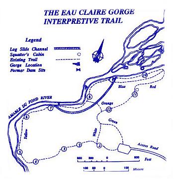
Location -The Eau Claire Gorge Conservation Area is located on the Amable du Fond River about 5 km off Rte 17 towards Kiosk in the community of Eau Claire. The most spectacular feature along the picturesque river is the gorge with water cascading between steep, majestic rock walls while the interpretive trail is a 1.9 km (1.2 mile) loop that takes about 1.5 hours to complete.
Transition Zone - This Area is part of the Great Lake – St. Lawrence Forest Region and is characterized by both evergreen and broad-leaved trees, such as the Eastern White Pine, Red Pine, Eastern Hemlock and Yellow Birch while the moderate slopes with the well-drained soils support a community of Popular, White Birch, Sugar Maple and Balsam Fir. About 11,000 years ago as glaciers retreated from this Area, the soil was removed leaving a hard bedrock surface. A thin layer of loam now exists due to the action of lichens and mosses over thousands of years of breaking down the bedrock. The combination of shallow, horizontal roots and thin soils give trees less stability, making them easy to be uprooted.
The Amable du Fond River – This quaint river, which originates at Pipe Lake within the boundaries of Algonquin Provincial Park, flows for 84 km (53 miles) in a northerly direction, dropping 263 metres (877 feet) to empty into the Mattawa River. The Amable du Fond River was allegedly named after an Indian Chief from the Montaignais tribe (Montreal area) who settled upstream from the gorge prior to 1848. Rivers were the roadways of the early lumbering industry and the Amable du Fond was no exception.
Logging History – The abundance of Red and White Pine attracted many loggers to this region in the 1850’s when lumber and square timber were in great demand for ship building in Britain. William Mackey was the first lumberman on the Amable du Fond River and his logs were guided downstream by a log slide constructed in 1870 to bypass the gorge to his sawmill at Crooked Chute Lake. A channel was dug alongside the gorge in which the slide, made of pine boards, rested on a foundation of pine logs while steel sleigh runners reinforced the curves and the bottom of the slide. It measured 370 metres (1233 feet) in length making it the longest slide on the Amable du Fond, hence, its nickname, "The Long Slide". At it’s opening, it measured 3.9 metres (13 feet) wide enough to allow 4 to 5 logs to pass through at one time. Piers were built on both sides of the river, joined together by a log gate to create a dam that served to raise the water level so that logs could be easily diverted into the slide. Timber was cut during the winter and piled on the ice to await the spring melt when lumbermen would guide the logs downstream. During the "log drive", the loggers established camps along the river where a shanty was built for the lumbermen close to the slide. J.R. Booth, a lumber baron from Ottawa who purchased the logging right in 1904, continued to use the slide to transport logs down the Amable du Fond River and further along the Mattawa and Ottawa Rivers to his mills until 1920. The dam was removed in the 1920’s when the log slide was no longer required. All that remains of the piers today are moss-covered timbers and rusting spikes. You can observe the shoreline upstream and notice how the bank bulges out to form two small spits of land. At first glance, these two unexplained spits can go unnoticed; however, they provide a link to historic events. This is the point where the log slide re-entered the river. As the logs fell from the slide to the river, sediment carried with them was deposited extending the shoreline, forming what you see today. It is still possible to trace the route of the "tote road" that was used to transport supplies from Eau Claire to Kiosk.
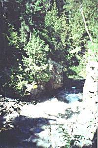
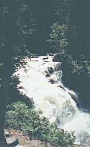
The Gorge – A fault ridge, extending across the Conservation Area, appeared millions of years ago when the bedrock split and dropped on one side. Where the river flows over this fault, erosion has worn away the bedrock thereby carving out the gorge. The water at the gorge descends 12 metres (40 feet) over a distance of 30 metres (98 feet), and the rugged valley walls rises 18 metres (60 feet) in an expression of nature’s supremacy. As you follow the trail, you will be walking down the fault ridge. The most spectacular scenic feature is the Gorge itself, where the Amable du Fond flows between steep rock walls in a dramatic series of rapids and waterfalls. Below the Gorge, the river widens and winds its way through a cluster of islands before flowing into Smith Lake.
The Squatter’s Cabin – Abandoned by lumbermen in the late 1930’s, this site became home for a squatter by the name of Godin, who left Quebec’s Gaspe to escape prosecution for the accidental shooting of his brother. He led a reclusive life, leaving in the 1940’s as mysteriously as he arrived. The cabin fell into disrepair; however, the structure you see today was reconstructed, in part, from a 1910 area building and with logs cut from the site. The techniques used in the construction are similar used by Godin. Using a broad axe, the logs were faced on two sides and stacked with the rounded sides adjoining. The dovetailing of the corners helped to secure the logs and shed water.
 Location -The Eau Claire Gorge Conservation Area is located on the Amable du Fond River about 5 km off Rte 17 towards Kiosk in the community of Eau Claire. The most spectacular feature along the picturesque river is the gorge with water cascading between steep, majestic rock walls while the interpretive trail is a 1.9 km (1.2 mile) loop that takes about 1.5 hours to complete.
 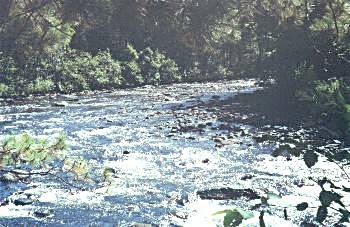 The Amable du Fond River – This quaint river, which originates at Pipe Lake within the boundaries of Algonquin Provincial Park, flows for 84 km (53 miles) in a northerly direction, dropping 263 metres (877 feet) to empty into the Mattawa River. The Amable du Fond River was allegedly named after an Indian Chief from the Montaignais tribe (Montreal area) who settled upstream from the gorge prior to 1848. Rivers were the roadways of the early lumbering industry and the Amable du Fond was no exception.