1:50,000 Topographic Maps Index for Woodland Caribou Provincial Park Return to the story Woodland Caribou Park - Good Land for Canoe Travelers

 
Index Map for 1:50,000 Topographic Maps
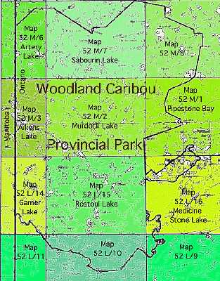
This index shows the 1:50,000 maps that you will need for navigation through the park. 

52 M/6 
52 M/3 
52 L/14 
52 L/11

52 M/7 
52 M/2 
52 L/15 
52 L/10

52 M/8 
52 M/1 
52 L/16 
52 L/9

If you're going to travel by canoe, you must get a current copy of the Woodland Caribou Park Map.  This map shows the canoe routes and portages.  The Park Map is available from the park office in Red Lake: 

Woodland Caribou Provincial Park 
P.O. Box 5003 
Red Lake, Ontario 
POV 2MO 
Telephone: (807) 727-2253 

You may also obtain the park map from the two sources listed below.


You will also need 1:50,000 topographical maps for navigating through the park. There are many places that sell these maps. Three sources are listed below: 

Woodland Caribou Park Map (canoe route map) and topographic maps of the park:


Northern Sporting Supplies 
P.O. Box 830, Howey Street 
Red Lake, Ontario, POV 2MO 
Canada 
Telephone: 807-727-2302
As of 9-14-99, $9.45 (Canadian) per map plus postage - JAH

Four Seasons Sport Shop 
Highway 105 
Ear Falls, Ontario  POV 2MO 
Canada 
Telephone: 807-222-2200 
As of 9-14-99, $8.75 (Canadian)per map plus postage - JAH


Topographic maps of the park only:

Federal Maps Incorporated 
Unit #1, 52 Antares Drive 
Napean, Ontario  K2E 7Z1 
Canada 
Telephone: 613-723-6366
As of 9-14-99, $9.95 (Canadian) per map plus $15 postage (air mail) per order - JAH

Return to the story Woodland Caribou Park - Good Land for Canoe Travelers
Copyright 2000 by James A. Hegyi  http://www.canoestories.com/wcp2mi.htm